Agriculture has long been under the scrutiny of the public for its environmental footprint on the landscape. The use of pesticides and herbicides are often vilified, synonymous with damage. Likewise, the production of livestock, mainly beef in the Peace Region, is viewed as cruel and damaging to the environment. In addition, it is recognized that all water on the landscape is linked to our creeks and rivers so that any contaminants on the land will end up in the water. What people fail to recognize is that the increased production and efficiency of both cropping and livestock production has increased substantially. Thanks to this, the country is able to maintain a “cheap food” policy and provide excess products to export. If the country was unable to export products, it would be unable to import those products we are unable to produce in our climate, like bananas.
Farmers go unrecognized as the greatest environmentalists; their livelihood, their families’ livelihood, and community rely on the sustainability and protection of the land. While profitability margins grow tighter and farmers are forced to be price takers in the current economic reality, some producers try to increase profitability by turning native vegetation areas into cropable acres or livestock production acres. Some environmentalists view this negatively. Many farmers are very conservative on the use of cropping inputs as tight economic margins discourage over the application and encourage the maintenance of effective buffers next to wetlands. Today’s livestock producers recognize the importance of using rotational grazing and exclusion of livestock from sensitive areas in protecting the ability of the land to produce forage. These practices emulate the natural grazing systems of wildlife in the past as large herds of bison denuded an area before moving on to “greener pastures”. In addition, people often forget, that farmers feed their families from the production of the land, the same as everyone else, so they are not going to knowingly produce unsafe or harmful food that will ultimately harm their family, community, or country.
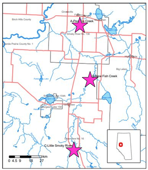
SARDA Ag Research began a water quality monitoring program in 2011, with the help of Aquality Environmental Consulting Ltd (Aquality) in order to measure the success of our producers in protecting the environment and water sources. Surface water samples were taken from three sites in SARDA’s research area: Peavine Creek, New Fish Creek, and the Little Smoky River. Sample locations, chosen by SARDA, were based on their proximity to agricultural lands, use as drinking water intakes, and their likelihood of exposure to terrestrial inputs. The Peavine Creek drains primarily cropland which would have a higher exposure to chemical fertilizers and crop protection products. The New Fish Creek drains an area considered primarily a livestock production area and includes large tracts of native pastures, tame pastures, and hay land. This area may be subject to the effects of manure and soil erosion. The Little Smoky River location is considered “pristine” with no agricultural land use upstream although other industries such as oil and gas and forestry are operating upstream. Although it was suggested that we sample several times per year to establish a baseline for water quality, it was determined that we could still determine that baseline over a longer period of time. This is due to other areas were doing the same water samples in their areas, we could compare our results with them to determine if we were different. If large differences were detected, water sampling protocols could be modified.
SARDA has been pulling samples at these three locations, spring, and fall, since the spring of 2011. These samples are tested for nutrients, bacteria, metals, and pesticides. We have tested in wet years and dry years. During these 9 years of testing, we have experienced producer adoption of new equipment, products, and practices. My observations indicate there is increased use of pre-seed burnoffs, fungicide applications, and pre-harvest applications of desiccants and weed control. Although minimum-till and no-till have been strongly adopted in the areas for many years, new management practices have further reduced tillage, soil, and water erosion. The generally accepted parameters of Alberta Environment and Parks Guidelines for river water quality are used to score each batch of samples.
So, what are we seeing in the results? Generally, the water quality in the spring is worse than in the fall. We can theorize that this happens because snowmelt washes the land of its contaminants and these end up in the watercourses. The metal score exceedances may be a result of the parent materials of the soils through which the water drains and soil erosion may strongly influence those results.
The sample site at Little Smoky River (hamlet) generally has the best water quality followed by the New Fish Creek area and then followed by the Peavine however this did not happen in 2019.
No pesticides or breakdown products have been detected at any of the sites since 2015. The water quality index for all three sites ranges from good to excellent. We have identified a trend that the water quality is generally improving, however, we do not have enough data to support significance yet.
Water testing is important to the area and to the agriculture industry as it supports the statement that farmers are great stewards of the land and the environment. This is a project that needs to continue. Look for the complete report for 2020 in SARDA Ag Research’s December Newsletter.
By Shelleen Gerbig, BSA, P.Ag., Extension Coordinator